More snow and ice to hit UK as thousands with no power after Storm Goretti
More snow, ice and freezing fog will hit the UK after thousands of people were left with no power after Storm Goretti.
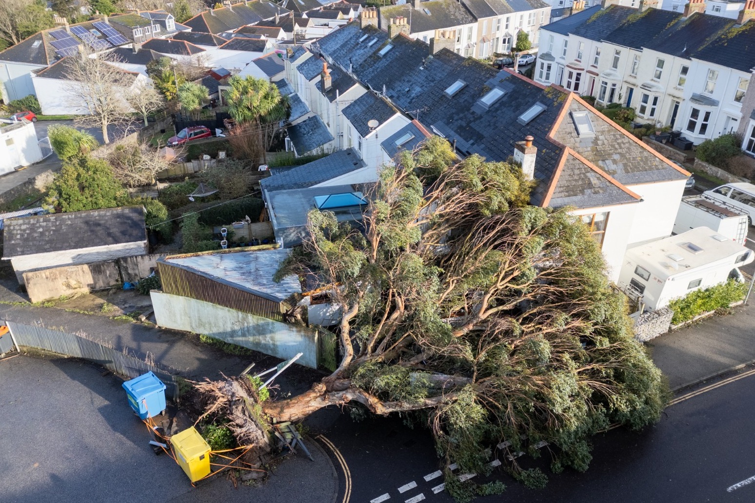
About 37,000 properties were without power in the South West at about 8pm on Friday, according to the National Grid’s website, along with about 3,000 in the West Midlands, more than 1,000 in the East Midlands, and about 240 in Wales.
The storm brought winds of almost 100mph after forecasters issued a rare red warning for “dangerous, stormy” winds in the South West.
Yellow warnings for snow and ice continue until Sunday and the Met Office warned Saturday morning will have a “very cold start” with icy stretches for many.
Forecasters also warned that the combination of melting snow and rain will increase the flood risk for some in the coming days.
Rail services across England, Wales and Scotland may be affected until Sunday, National Rail said.
Residents on a tidal island near Cornwall woke to more than 80 trees brought down by Storm Goretti.
The head gardener of St Michael’s Mount, Darren Little, said he was heartbroken to see the island on Friday morning, with damage 10 times worse than any other storm impact in the decades he has lived there.
The island has a weather station which recorded winds of 111mph on Thursday evening before a power cut which lasted until Friday morning, Mr Little said.
He added: “It’s more devastating for us as a gardener seeing the hard work you’ve done over many years, then everything’s wiped out within about six hours.”
Downing Street said support was being offered to homes left without power.
Forecasters recorded 15cm of snow at Lake Vyrnwy in Powys and 7cm at Preston Montford in Shropshire and Nottingham.
In Scotland, there was 27cm at Altnaharra in Sutherland, 26cm at Loch Glascarnoch and 22cm at Durris in Kincardineshire.
The lowest temperature recorded overnight was minus 13.3C at Braemar, Aberdeenshire, while a peak gust of 99mph was reported at St Marys on the Isles of Scilly, the highest there since 1991, according to the Met Office.
The highest rainfall total was recorded in Cornwall, with 61.8mm at Colliford Dam, followed by 57mm at Ddolwen Bridge, Dyfed, and 54mm at White Barrow in Devon.
The Government has been urged to convene a meeting of the emergency Cobra committee.
Gideon Amos, Liberal Democrat MP for Taunton and Wellington in Somerset, said: “The Government’s Cobra committee must urgently be convened to ensure fast help is delivered across the region.
“The South West is routinely overlooked by the Government, but we cannot be ignored in this time of need.”
Steve Willington, Met Office chief forecaster, said more snow is possible on Sunday, after a “largely dry” Saturday away from north-eastern parts of Scotland and England.
A yellow warning for snow and ice will be in force for much of Scotland from 2am until 3pm on Sunday.
Mr Willington said: “A further 2-5cm of snow is possible to accumulate at low levels within the warning area on Sunday, with 10-20cm possible over higher ground. With much of this falling in areas that have already seen severe snowfall, ongoing disruption is likely.
“Those in central and southern England and Wales will see this fall as rain, in what will be a wet Sunday for many.”
A yellow warning covering large parts of Scotland, the East and West Midlands, north-east and north-west England and Yorkshire will be in place from 2am until 3pm on Sunday.
Yellow weather warnings for snow and ice have been extended into Saturday for large parts of Scotland, England and Northern Ireland.
A yellow warning for snow and ice is in place until 3pm on Saturday, with further snowfall possible across parts of northern England and much of Scotland, while a widespread risk of ice is expected to cause disruption.
A separate yellow warning for ice covers large parts of England and Wales until midday on Saturday as partially thawed snow refreezes, accompanied by wintry showers and freezing fog.
In Northern Ireland, a yellow warning for snow and ice will run until 11am on Saturday, with the Met Office warning of icy patches and some hill snow.
At least 69 flights scheduled to or from Heathrow Airport were cancelled on Friday, disrupting more than 9,000 passengers.
The majority of the cancellations were short-haul flights by British Airways.
In a statement issued just after 6am, East Midlands Airport said its runway had reopened after being closed overnight due to heavy snow on the runway.
Birmingham Airport said at 7.15am that its runway had reopened on a “reduced basis” and teams were working to get passengers moving as efficiently as possible.
The storm, named by French weather forecaster Meteo France, was described as a “multi-hazard event” by the Met Office.
Elsewhere, several shipping containers fell from two vessels off the Isle of Wight overnight, according to the Maritime and Coastguard Agency.
A number of refrigerated containers were reported falling into the sea from a cargo ship near Nab Tower at 11.10pm on Thursday and seven empty containers fell from the second ship which was 16 nautical miles south of St Catherine’s Point, Isle of Wight, at 11.55pm.
In Penzance, the stadium of the Cornish Pirates rugby club was damaged, with the roof on the main grandstand at Mennaye Field having large chunks torn off it by the wind.
Dozens of schools across the Midlands and Wales were closed on Friday where the amber weather warning was issued.
More than 250 schools were expected to remain closed in Scotland, including more than 150 in Aberdeenshire, dozens in the Highlands and Aberdeen, plus a number in Moray.
Disruption on the roads also affected the criminal justice system on Friday, with no remand prisoners being transported to Birmingham Crown Court.
Published: by Radio NewsHub